Detours & closures
Planned disruptions are subject to change due to weather or other unforeseen circumstances. Updates will be posted as soon as possible. We recommend turning on notifications for service alerts in your Metlink app account.
Route 23 detour: Hornsey Road closure
Dates
Monday 23 to Friday 27 November 2026
Times
Route 23 buses will be on a detour between the hours of 9am to 3pm each day.
- From Wellington: the 8:32am service will be the first to detour, and the 2:16pm service the last.
- From Houghton Bay: the 9:15am service will be the first to detour, and the 2:30pm service the last.
Road may reopen during the works period
Although this closure is advertised from Monday 23 to Friday 27 Nov, the road is expected to reopen earlier. We'll update this page as soon as possible with the latest information.
If work is postponed due to wet weather, the road will temporarily reopen until work can resume. Route 23 buses will return to their normal route while the road is open.
What is happening?
Contractors are undertaking chip sealing, due to the width of the road, a road closure is required.
As a result, Route 23 buses will be on detour and will not travel via Hornsey Road, Sutherland Road, Manchester Street, Roy Street or Mansfield Street between 9am and 3pm.
Detour route
Route 23 buses will operate via Riddiford Street, Russell Terrace, Mt Albert Road and Houghton Bay Road in both directions.
Route 23 detour Map
Zoo walking map
(Scroll down to view the detour and walking maps)
Travelling to Wellington Zoo
If you're visiting Wellington Zoo during the detour, you can get off at the temporary bus stops outside, or opposite, 16 Russell Terrace.
These temporary stops will also be served by Route 29 buses while the detour is in place.
The temporary stops are approximately 600m from Wellington Zoo, which is about a 9-minute walk.
Can I use Route 29?
Yes.
Route 29 buses will also serve the temporary stops at Russell Terrace during the detour and may be a convenient option for travel to and from Wellington Zoo
What stops can I use?
The following stops will remain available during the detour:
- Temporary stop outside 16 Russell Terrace (near Riddiford Street)
- Temporary stop opposite 16 Russell Terrace (near Riddiford Street)
- Stop 7931 Houghton Bay Road at Hornsey Road
- Stop 6931 Houghton Bay Road at Hornsey Road (near 57)
Plan your journey
Please allow extra travel time while the detour is in place.
Use the Metlink app, or Live Tracking for the latest information.
When will my bus arrive?
You can use Live Tracking to see your bus location and estimated arrival time.
Select Switch direction if require
What stops are closed?
The following stops will not be served by Route 23 between 9am and 3pm during the closure:
Stop 6921 Mansfield Street at Horner Street
Stop 7922 Mansfield Street (near 320) (remains open to HX)
Stop 6922 Mansfield Street at Roy Street (near 311)
Stop 7924 Wellington Zoo - Stop A
Stop 6924 Wellington Zoo - Stop B
Stop 7925 Manchester Street opposite Caprera Street
Stop 6925 Manchester Street at Caprera Street
Stop 7926 Sutherland Road at Sutherland Crescent
Stop 6926 Sutherland Road at Rodrigo Road
Stop 7927 Hornsey Road at Auckland Terrace
Stop 6927 Hornsey Road opposite Auckland Terrace
Stop 6928 Hornsey Road at Sunglow Avenue (near 47)
Stop 7928 Hornsey Road opposite Sunglow Avenue (near 49)
Stop 7929 Hornsey Road (near 57)
Stop 6929 Hornsey Road (near 65)
Stop 7930 Hornsey Road (near 48)
Stop 6930 Hornsey Road (opposite 50)
Need help?
Contact Metlink on 0800 801 700 or visit the Metlink website for help planning your journey.
Detour Map- Walking Route to Wellington Zoo
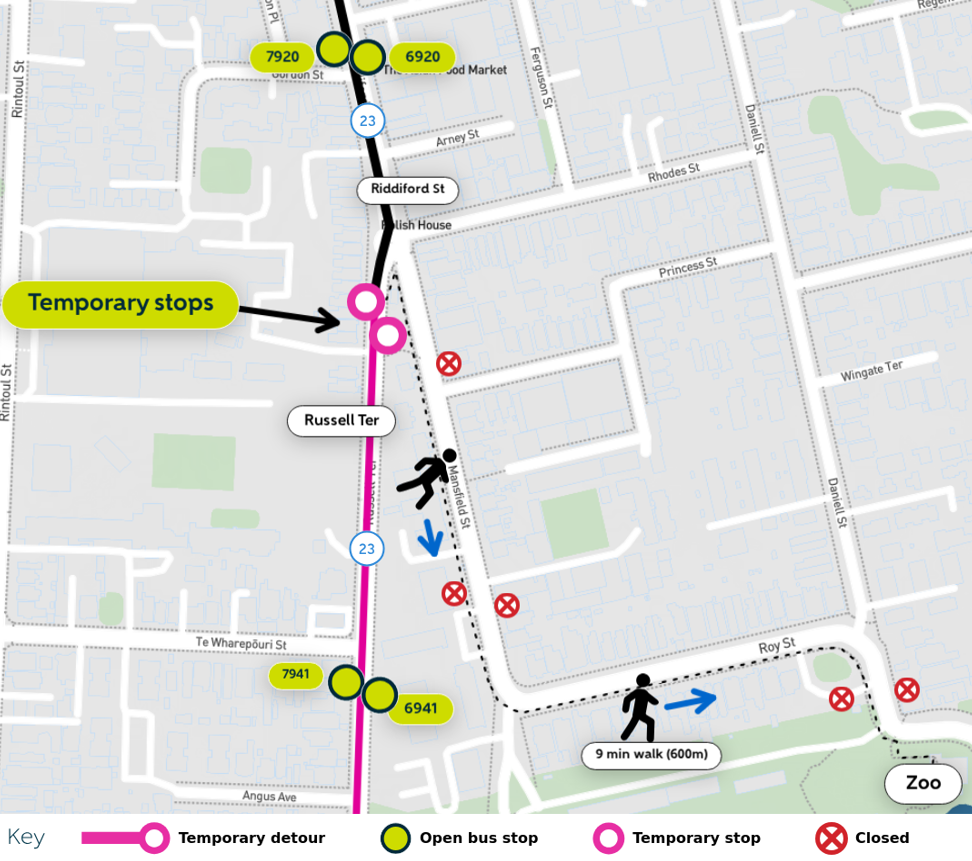
Detour Map for Route 23
Newtown: Route 1 and school buses 654, 725, 726, 731 detour during Rintoul Street works
Dates
Wednesday 6 January to Friday 5 February 2027 (or when works end)
Times
Buses will be diverted from the start of service on Wed 6 Jan. The diversion will remain in place 24 hours a day, 7 days a week until Friday 5 Feb.
What is happening?
Rintoul Street is closed between Stokes Street and Millwood Street. The closure will allow essential wastewater renewal works along Rintoul Street, including replacing ageing underground pipes and upgrading wastewater infrastructure.
During the closure, bus services are detoured via Riddiford Street with Rintoul Street bus stops temporarily closed.
What bus routes are impacted?
- Route 1
- School routes 654, 725, 726, 731
Detour route
Buses will operate between Riddiford Street, Russell Terrace, Te Wharepōuri Street and Rintoul Street in both directions.
Maps
- Route 1/School Routes 654, 725,726,731 detour Map
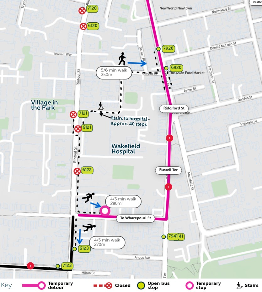
- Wakefield Hospital walking map
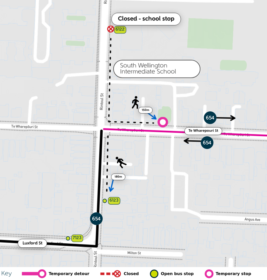
- South Wellington Intermediate alternate stops
Scroll down to view the detour and walking maps
What stops are closed?
The following stops will be closed.
- 6119 Rintoul St at Newtown Shops
- 7120 Rintoul St at Stoke St
- 6120 Rintoul St (near 63)
- 6121 Rintoul St at Wakefield Hospital
- 7121 Rintoul St opposite Wakefield Hospital
- 6122 South Wellington Intermediate School (school stop)
Temporary bus stop
-
A temporary stop is located at 32 Te Wharepōuri Street
Where can I catch my bus during the detour?
Towards Island Bay
- Stop 6119: Use stop 6019, Riddiford St at Newtown Shops, approximately 150m away.
- Stop 6120: Use stop 6019, Riddiford St at Newtown Shops, approximately 450m away, a 7–8 min walk.
- Stop 6121 (Wakefield Hospital): Use stop 6123, Rintoul St (near 191), approximately 270m away, a 5-minute walk with a slight uphill gradient.
Towards Wellington City
- Stop 7120: Use stop 7019, Riddiford St at Newtown Shops, approximately 400m away, a 6–7 min walk.
- Stop 7121 (opposite Wakefield Hospital): Use the temporary stop at 32 Te Wharepōuri St, approximately 280m away, a 4–5 min walk.
For stops 6120 and 7120: Pedestrian access between Rintoul Street and Riddiford Street is available via Millward Lane. Please note this route includes several stairs.
Travelling to Wakefield Hospital
Your nearest stop is 6123, Rintoul Street (near 191). Wakefield Hospital is approximately 270m away, a 5-minute walk with a slight uphill gradient.
Travelling from Wakefield Hospital
Use the temporary stop at 32 Te Wharepōuri Street, approximately 280m or a 4 to 5-minute walk from Wakefield Hospital.
Plan your journey
Please allow extra time while the detour is in place.
Use the Metlink app, or Live Tracking for the latest information.
How can I check when my bus is due?
Travelling towards Island Bay
Check real-time arrivals for Wellington Hospital – Stop A (6055). This stop is before the detour begins, so it can give you an indication of when your bus is approaching.
Real-time information:
Stop 6055 – https://www.metlink.org.nz/stop/6055(external link)
Travelling towards Wellington City
Check real-time arrivals for Stop 7123 – Luxford St at Rintoul St. This stop is before the detour begins, so it can give you an indication of when your bus is approaching.
Real-time information:
Stop 7123 – https://www.metlink.org.nz/stop/712(external link)3
Live bus tracking
You can also use Live Tracking to see your bus location and estimated arrival time.
- Route 1 to/from Wellington City: https://www.metlink.org.nz/service/1(external link)
- School 654: https://www.metlink.org.nz/service/654(external link)
- School 726: https://www.metlink.org.nz/service/726(external link)
- School 725: (external link)https://www.metlink.org.nz/service/725(external link)
- School 731: https://www.metlink.org.nz/service/731(external link)
Select “Switch direction” if view buses travelling in the opposite direction.
Need help?
Contact Metlink on 0800 801 700 or visit the Metlink website for help planning your journey.
Route 1 and school routes 654, 726, 725, 731 detour map
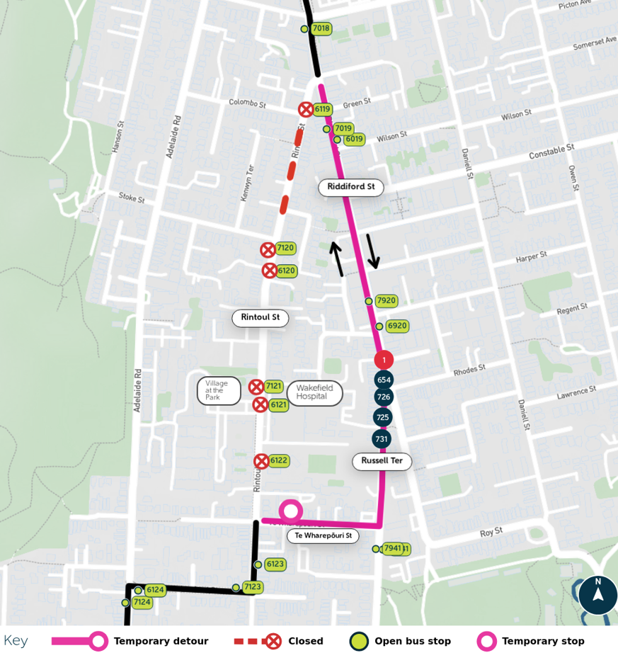
Wakefield Hospital walking map
South Wellington Intermediate alternate stops
(work is weather dependent and dates are changing)
Last bus before detour from Miramar Mon-Fri 8:40am
Sat 8:10am
First bus after detour from Miramar Mon-Fri 4:20pm
Sat 4.10pm
Last bus before detour from Johnsonville Mon-Fri 7.30am
Sat 7.45am
First bus after detour from Johnsonville Mon-Fri 3.45pm
Sat 3.45pm
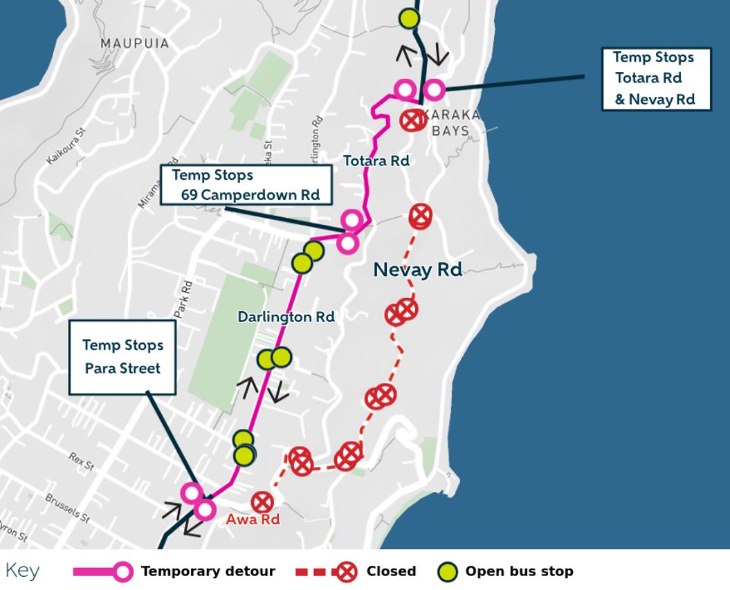
During the work hours, buses detour between Totara Rd, Camperdown Rd and Darlington Rd.
Scroll down for map.
Temporary Bus Stops
Northbound bus services towards Mt Crawford
- Outside The Local Garage at 91 Para St, located near Awa Rd Intersection
- Outside 69 Camperdown Rd and opposite
- At the top of Totara Rd near Nevay Rd and Napier St Intersection, at 174 Totara Rd
Southbound bus services from Wellington City toward Miramar Shops
- Located at 124 Nevay Rd near Totara Rd and Napier St Intersection
- located opposite 69 Camperdown Rd
- Located 80 Para St, near Awa Rd intersection
Bus Stops Closed during work hours
- Stop #7270 Awa Rd at Nevay Rd(external link)
- Stop #6270 Awa Rd at Seatoun Heights Rd(external link)
- Stop #7269 Nevay Rd (opposite 16)(external link)
- Stop #6269 Nevay Rd (near 18)(external link)
- Stop #7268 Nevay Rd (opposite 50)(external link)
- Stop #6268 Nevay Rd (near 56)(external link)
- Stop #7267 Nevay Rd at Taipakpaku Rd(external link)
- Stop #6267 Nevay Rd (near 94(external link))
- Stop #7266 Nevay Rd at Totara Rd(external link)
- Stop #6266 Nevay Rd (near 122)(external link)
- Stop# 7272 Awa Road at Para Street
- Stop#6271 Awa Road at Totara Road (near 32)
- Stop#7271 AwaRoad at Totara Road
Detour Map
Last published: Friday, 7 August 2026 at 12:58 pm